Rock Glacier Trail

Trail Length: 3.2 km ( 2.1 mi )
Difficulty: Difficult
Park Amenities:
Kluane National Park & Reserve, Haines Junction, Yukon Territories, Canada
Rock Glacier Trail
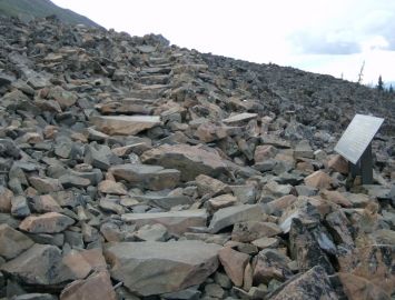
 The 3.2 kilometre ( 2.1 mi ) hiking route follows a boardwalk, saw dust and rock slide trail leading up to the toe of the rock glacier and a viewing platform. "Nju`tàda" is the term used by the First Nation people of the region to identify the mountain range on which the Rock Glacier Trail is located.
The Rock Glacier Trail is a challenging elevation hike. It may be a short trail but the route is mostly up hill. There are many steep sections hiking over boulders and rocks where the trail follows a series of mini rock cairns. The route has an elevation gain of about 90 metres (300 feet) and should take hikers no longer than 1-2 hours to complete.
The Rock Glacier Trail explores various eco systems. Down low there are marsh like conditions and at the higher elevations it becomes barren as you navigate the slopes of a rock slide.
Along the entire route are interpretive signs leading you all the way to a viewing platform. From the viewing platform there are views overlooking the valley, mountains and Dezadeash Lake.
This hiking route is well maintained but there are challenges. The trail does travel over rock slides which do require sure footing. The trail does lead up into the alpine slopes where you are exposed to the elements. It is important to prepare for the weather and to have good footwear on this adventure.
There are no services at the trailhead of the Rock Glacier Trail.
Explore the Rock Glacier Trail in Kluane National Park & Reserve, Haines Junction, Yukon Territories, Canada
Address:


