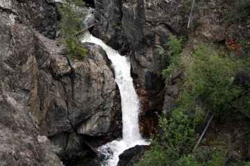
Van Gorder Waterfall Trail

Trail Length: 1.5 kilometre
Difficulty: Easy - Family
Park Amenities:
Van Gorder Waterfall Trail
Faro, Yukon Territories, Robert Campbell Region, Canada
Van Gorder Waterfall Trail in Faro, Yukon Territories, Robert Campbell Region, Canada is a highlight trail in the village. The recreation route is for hikers and walkers only. It is one of the most popular day hikes in the area highlighted by a viewing platform overlooking the Van Gorder Falls.
The one-way 1.5 kilometre trail leading to the waterfall explores mountain ridges, a forest, a creek valley and a rocky cliff. It is when you reach the edge of the cliff and the canyon that you will find a wooden viewing deck looking out over a waterfall.
The hiking trail, creek and waterfall are named after Del Charles Van Gorder. He was a miner and fur trader who settled in the area in the early 1900s.
The closest trailhead entrance so to access the Van Gorder Falls Lookout as quickly as possible is by accessing the Fox Trail. The Fox Trail begins at the end of McQuesten Road. Follow it to the first path on your left. The path has no trail markings on our visit but it was easily identified by the wooden edging. The path with edging is the Van Gorder Falls Trail.
From the main trailhead in the community of Faro, the Van Gorder Falls Trail crosses Ross Road before it begins to work its way uphill through a forest of aspen trees. Just after Ross Road there is a junction where one can connect with the Bear Trail.
Continue to follow the Van Gorder Falls Trail a little further and there are two more trailhead entrances. This time it is the Fox Trail and Wolf Trail. Continue hiking pass the junction of trails until you reach a rocky ridge. Follow the trail along the ridge a short distance and it will soon drop into a river valley. At the bottom of the valley there is a footbridge crossing over Van Gorder Creek.
From the creek bridge continue to follow the trail up the opposite river bank. At the top of the river bank are a few more corners and a rocky cliff with a wooden lookout platform overlooking Van Gorder Falls. The lookout is railed for protection and there are some sitting benches.
There are some steep hills on the trail. For your convenience there are some resting benches placed at the top of some of the bigger hills.
Van Gorder Waterfall Trail in Faro, Yukon Territories, Robert Campbell Region, Canada
Address:
How To Get ToVan Gorder Waterfall Trail
:The closest trailhead entrance so to quickly access the Van Gorder Falls Lookout is by hiking the Fox Trail. It begins at the end of McQuesten Road in Faro. Follow Fox Trail to the first path on your left. It was not marked on our visit but it is easily identified by the wooden edging. The path with edging is the Van Gorder Falls Trail.


