Bruce Peninsula Cliffs and Caves
This morning I said my good byes to Steve before I deported Norms Campground in Kagawong on Manitoulin Island. Great guy. Treated me well. And I thanked him for my campsite on the waterfront of Lake Kagawong. “I’ll back,” I said as I drove off into the sunrise with my trailer pod in tow.
My next destination was South Baymouth, which is on the southern coast of the island. In South Baymouth was a 10 AM sailing with my name on it awaiting to take me to Tobermory on the Bruce Peninsula on the Ontario mainland.
The sailing took 1 hour and 45 minutes. The boat was huge. It reminded me of the ferries in BC between Vancouver Island and Vancouver in many ways – minus the mountains. I was anxious to see what adventure was around the corner. I was not sure exactly what to expect in Tobermory as the literature was scarce.
Tobermory, I found out, is a small little village, with eclectic shops, a waterfront walkway and easy access to marine tours and rentals. The small Georgian Bay community is located on the doorstep to two big parks – the Five Fathoms Marine Park and the Bruce Peninsula Park. The trailhead to the 800+ kilometre Bruce Trail begins in the Bruce Peninsula Park and follows the coastline to Niagara. Much of the trail is hiking trails with some sections following gravel and paved roads.
Five Fathoms Marine Park, just off the coast of Tobermory, attracts scuba divers, kayakers and boats to the region in big numbers. Many wanting to view the limestone cliffs and explore the islands in the park. Some stay in the park and enjoy a few nights from one of the many wilderness camping locations in the park.
Bruce Peninsula Park is located just south of Tobermory. It covers a large portion of the east coast of the Bruce Peninsula. There are viewpoints, beaches and many hiking trails. What you do depends on which of the 5 access points to the park you use. The access points include the Visitor Centre, Singing Sands, Little Cove, Campground and the Log Dump – each providing a different outdoor experience.
In Tobermory I stayed at the only private campground in the community. There must of been over 50 campsites. I think I was 1 of 3 people in the park. Sad really. Beautiful weather, scenery and atmosphere and the park was empty.
I was up the next morning early and arrived at the Visitor Centre in the Bruce Peninsula Park to check out the high tower lookout and to hike some of the trails to the coastline. The visitor centre was closed. Oh well, early bird catches the worm and I was to the tower. I climbed to the top viewing deck and checked out the views. Lucky I am not scared of hieghts because the stairs were grated and you could always see the ground no matter how high you climbed the bottom was always in view.
Click, click – took some pictures and off I went to hike to Dunks Bay. It was an easy going hike, through the forest leading to a viewing deck, a boulder beach and a trail connecting to the Bruce Trail. The hike was a great way to start the morning. It was relaxing and not difficult at all. At the boulder beach I took some time to enjoy the warmth of the morning sun on my face.
The highlight of the day were the hiking trails which started from the campground access point of the park. The trail was a treat. The trail included rock steps and tree root stairwells. It lead me to another massive boulder beach, some cliffs and to an underwater cave. All were part of the Bruce Trail.
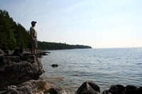
The trail’s first highlight was the boulder beach. Little rock statues marked the route. I veered left as I saw a trail access at the end of the beach which would lead me to the cliffs and viewpoints – in particular the “Overhanging Rock” lookout. It was marked on my map as a good viewpoint and the picture looked wicked. But, I soon found out – what was marked on the map was not marked on the trail. So, after numerous attempts up some side trails I finally found the elusive lookout.(main BLOG photo).
I unloaded the backpack and took some pictures. I had my lunch and relaxed in the sunshine. As I was gazing and poking around among the boulders on the cliff I spotted another hanging rock, just like the one I was on. Hmmm.. I thought – that one over there looks allot like the picture of the “Overhanging Rock’ on the map. I pulled out the map with the picture and soon figured out I was at the wrong cliff . It ends up my version of the “Overhanging Rock ” was better as it had boulders to sit on and and was out of view from the trail.
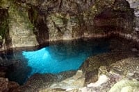
I hiked back to the boulder beach and proceeded to jump from one boulder rock to another until I could pick up the trail again at the other end of the beach. The trail this time was to lead me to what is called the “Grotto”. It is a cave with an underwater pool and tunnel which leads swimmers to the open water. To access the cave you have to scale down a cliff . Now it was getting fun.
There was another couple there also talking with some locals about the “Grotto”. I arrived and listened in for a few minutes and then proceeded with no hesitation down the cliffs. Scaling down was a breeze as there were plenty of holds. In the cave you could see the ubderwater tunnel leading under the cliffs. But, nobody I talked to knew how long the tunnel was, but they all said people swim from one end to the other. Not on this day.. for this guy. I like my air and running out of it underwater does not seem fun for me. I was content to enjoy the cave from above. I love adventure but I am no dummy. I want to live another day for another adventure.


Leave a Reply
Want to join the discussion?Feel free to contribute!