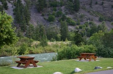
Naxwit Picnic Site

Park Amenities:
Naxwit Picnic Site and Day Use Area in Lillooet, Cariboo-Chilcotin Region, British Columbia, Canada is a very well maintained day-use-only site with plenty of informational billboards highlighting the history and wildlife of the region. The entrance is well marked and includes a very large, bus and RV friendly, parking lot.
The park rests on the shores of the Seton River wedged up against some giant, granite canyon walls. The river valley, opens up, providing great mountain and river views. Exploring the nearby trails, rivers, lakes and gravel roads provides an opportunity to view some of the local wildlife and maybe, find, a pictograph.
Naxwit is a popular stop for travelers for a picnic and to stretch weary legs. Onsite, in the park, is a selection of 14 picnic tables, some on the shore of the river while others in the shade of trees. Nearby, in the parking lot is a washroom and some drinking water.
Naxwit is the name given to the park from the Stl'atl'imx First Nation people. As the land once was the traditional lands of the First Nation people. Translated Naxwit means "snakes" named after the many Garter Snakes in the area.
Explore the Naxwit Picnic Site and Day Use Area in Lillooet, Cariboo-Chilcotin Region, British Columbia, Canada
Address:


