Golden
British Columbia
Canada
Difficulty: ModeratePark Amenities:
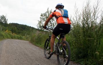
Moonraker Trails are a network of mountain biking trails and gravel roads located south of the community of Golden, BC in the Kootenay region of British Columbia, Canada. The trails are mostly single track routes. The gravel roads are mostly rough and rugged forestry service roads.
The gravel roads and trails in the Moonraker Trail Network explore through forests, navigate along rivers and creeks and visit remote forestry lakes. The lakes include Little and Big Cedar and Sander Lakes. The creeks in the area include Canyon, Cedar and Tallis Creeks. Cedar Lake being the more popular lake in the region as it is closer to Golden and includes a small forestry campground.
The Moonraker trails and roads are popular for hiking, mountain biking and horseback riding in the summer months. During the winter months the network of trails become routes for snowshoeing and cross country skiing.
The trails in the region include the Cedar Snag (4.2 km), North Star (3.8 Km), Bear Claw (2.9 Km), Moonraker (1.3 Km), Devil's Slide ( 0.7 Km), Klahowya (1.3 Km), Bear Cub (0.25 Km), Ptarigan (2.4 Km), Kissima Lookout (0.8 Km), Canyon Creek (17 Km), Wapiti Ridge (0.6 Km) and the Windigo Chute (0.6 Km).
It is important to bring bug spray as there are many bugs in the area especially around the lakes and creeks. It is also bear country, so make plenty of noise when exploring. Lastly, on some of the higher elevation routes watch for mountain goats.
Moonraker Trails, Golden, BC, Canada in the Kootenays
Address:
Moonraker Trails - Mountain Biking
Dogtooth Canyon Forest Service Road
Golden
Canada
How To Get ToMoonraker Trails - Mountain Biking
:
How to Get Here: When in Golden travel along 10th Ave North to 7th Street North. Follow 7th to Kicking Horse Drive which follows the Columbia River. Follow the river to a bridge which crosses over the river leading to the mountain resort. Just past the bridge, before a big corner going up the hill is a dirt road on your left. The road is called the Dogtooth Canyon Forest Service Road. Follow the gravel road to Cedar Lake and the trails.
No reviews yet for Moonraker Trails - Mountain Biking.

