Revelstoke
British Columbia
Canada
Trail Length: 1-2 kilometresDifficulty: ModeratePark Amenities:
Begbie Falls is fabulous waterfall find located south of the community of Revelstoke, BC., Canada. Thew waterfall is located where Begbie Creek empties into Upper Arrow Lake. Begbie Falls is accessed by various hiking routes and by one rough, narrow, gravel road. The journey to the falls depends on your physical abilities (hike in) or the type of vehicle (drive in).
The shortest hiking route to Begbie Falls involves driving a rough gravel road (big pot holes and very narrow) to a gravel parking lot located at the Begbie Falls Recreation Site (directions below). Some park their vehicle at the start of the rough gravel road section and hike or bike the rest of the road to the parking lot and the trailhead. In many cases this is a safer option.
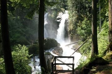
The short 10 - 20 minute hiking trail leading downhill from the parking lot is full of twists and turns eventually connecting to a series of wooden stairs leading to a viewing platform located at the base of the falls. Remember what hikes down, must hike up. It is a work out coming back up.
From the viewing platform the falls drop to the ground right in front of your eyes. In high run-off seasons it is loud, the mist engulfs you, the temperature drops and... you bathe in dew drops. It is a photo moment.
Be reminded the hard packed earthy trail leading to Begbie Falls does have some sections with exposed tree roots and rocks. And the hiking trail can be very slippery from the mist created from the waterfall, (especially going downhill) as you get closer to the viewing platform. Proper footwear is always a good idea. After enjoying the falls, back track a few hundred metres from the viewing platform, and the trail connects to the shores of Upper Arrow Lake. A great spot for a picnic.
Begbie Creek Trail explores for 2 kilometres through the forest trees, mostly within an ear shot of the creek rapids and sometimes within sight. The longer trail explores along the creek, navigating trees, crossing a wooden foot bridge leading to the Begbie Falls Recreation Site and, from there, you know the story - it is then 10 -20 minutes down to the waterfall viewing platform.
Address:
Begbie Falls
Revelstoke
Canada
How To Get ToBegbie Falls
:
How to Get Here: Follow Highway 23 south from the junction for about 3 kilometres. Turn left on Mt. Begbie Road and continue along the paved road, following the road signs to the gravel access road. From here you must decide if you want to park and hike the rough road (if you do not have a tough off road vehicle) or continue along the gravel access road to the parking lot at the Begbie Recreation Site.
No reviews yet for Begbie Falls.

