Redstreak Trail - Kootenay National Park

Radium Hot Springs
British Columbia
Canada
Park Size: 1,406 sq. kilometres
Trail Length: 2.3 kilometre one-way
Difficulty: Moderate
Park Amenities:
Redstreak Trail is a 2.3 km hiking adventure exploring a river eco system before connecting with Redstreak Mountain. The trail is located in the Kootenay National Park of British Columbia, Canada near the Village of Radium Hot Springs.

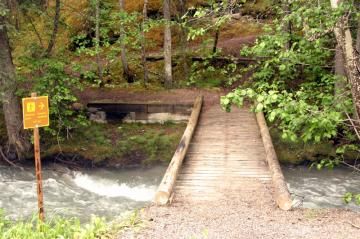
The Redstreak Trail begins by walking over a small boardwalk footbridge that crosses the Sinclair River before heading into the trees. The forest consists of white spruce, lodgepole pine, douglas fir and aspen trees. Once in the trees, the trail follows the banks of the Redstreak Creek to the base of Redstreak Mountain.
The one-way trail follows along an earthy, pine-needle covered path, much of it, under the cover of trees therefore receiving little sunshine. Because of the forest cover, the moisture coming from the creek and the changing weather temperatures the trail is, often, slippery and wet therefore prone to accidents. There are exposed tree roots, deadfall trees and river rock located along the trail. Good footwear, water and layering of clothing is important for an enjoyable time on this hike.
The best time for hiking this trail is from Mid July to late August. The total elevation gain during the hike is only 193 metres but, still, there are a few switchbacks along the route. Overall the Redstreak Trail is an easy grade trail and a very nice way to view the wilderness in the Kootenay National Park..
Kootenay National Park near Radium Hot Springs in British Columbia, Canada.
Address:
Redstreak Trail - Kootenay National Park
Highway 93
Radium Hot Springs
Canada
How To Get ToRedstreak Trail - Kootenay National Park
:How to Get Here: From Radium Hot Springs travel along Hwy #93 into the Kootenay National Park. Enter the park through the 'west gate' . Continue past the gate for 4.4 kilometres to the parking area and trailhead.
No reviews yet for Redstreak Trail - Kootenay National Park.


