North Delta Watershed Park

Park Size: 153+ hectares
Trail Length: 11+ kilometres
Difficulty: Easy - Family
Park Amenities:
The parkland sits on top of an artesian water supply and measures over 153+ hectares (375 acres). The park is a forested parcel of land protected from logging, bordered by commercial, residential and industrial streets.
Highway 10 is the southern perimeter and 64th Avenue is the northern perimeter of the park. To the east is Scott Road and to the west is Highway 91 and the Burlington Northern Rail corridor.
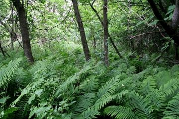
The North Delta Watershed Park is a heavily forested park covered in Douglas Fir, Western Hemlock and Western Red Cedar trees. In the middle of the park is an open meadow and day use picnic site.
There are over 11 kilometres of wilderness trails. The main trails in the park include the Lower, Upper, Canyon, Water Tower, Pinewood, Shed Bike, Gravity Bowl and Briarwood Trails.
There are hiking-only trails and there are trails which are shared trails with hiking, biking and horseback riding. The routes explore along gravel paths and deactivated logging roads. Located along the trail routes are information billboards, bridges, trail signs and trail maps.
The mountain biking trails in the park are not well identified based on level of experience and level of difficulty. Some trails include teeter-totters, ramps, ladder bridges, drop offs, gaps, skinnies and tabletops... you just have to find them.
The main open area in the North Delta Watershed Park is the ``Meadow``. The ``Meadow`` includes a day use picnic area, picnic pavilion and washrooms. The pavilion can be booked through the local Parks, Recreation & Culture office for day-use events and groups.
The ``Meadow`` is also the site for enjoying some of the best views in the park. There is a natural look-out area with views of Mud Bay.
Explore North Delta Watershed Park near Delta, Ladner, and the Tsawwassen BC Ferry Terminal in British Columbia, Canada
Address:
How To Get ToNorth Delta Watershed Park
:From Delta, BC, Canada travel south on 112th Street. Take a right onto 72nd Avenue and then a left on Westview Drive. From Westview take a left on 64th Avenue and continue to Kittson Parkway.


