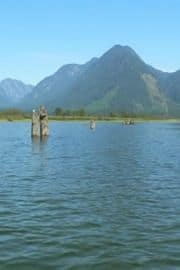
Pitt Lake

Park Amenities:
The Pitt River enters the lake from the north and empties the lake in the south. There are a number of wetland, marsh and bog areas located near the southern mouth of the Pitt River where it meets Pitt Lake.
The lake is bordered by four parks. The eastern shoreline of Pitt Lake is shared with the Golden Ears Provincial Park. The western shoreline is shared with the Pinecone Burke Provincial Park. The north end of the lake and Pitt River are under the shadow of the Garibaldi Provincial Park. The south end of Pitt Lake is protected by the Grant Narrows Regional Park and the Pitt-Addington Marsh Wildlife Management Area.
The lake is over 24 kilometres wide and 4.5 kilometres wide. The south end of the lake is the only point of access by road because of the surrounding mountainous terrain. Grant Narrows Regional Park provides the best access point to the lake. There is a boat launch and canoe and kayak rentals in the park.
The main activities enjoyed on Pitt Lake are boating, fishing, birdwatching, sightseeing, swimming, kayaking and canoeing. Most come to Pitt Lake for fishing trout and for birdwatching near the wetland areas.
Explore Pitt Lake in Pitt Meadows, British Columbia, Canada
Address:
How To Get ToPitt Lake
:From Pitt Meadows travel north on Harris Road. Travel about 4 kilometres and then take a right on McNeil Road. Continue east to Rannie Road and take a left. Continue traveling north to the park, follow the signs. It is 18 kilometres from Pitt Meadows.


