Cypress Falls Trail


Print
cypress-falls-trail
West Vancouver

Trail Length: 2-3 kilometres return

Difficulty: Easy - Family
Park Amenities:
Hiking
Picnicking
Sightseeing
Waterfall


Cypress Falls is a hiking trail exploring a forest and leading to two natural viewpoints overlooking a waterfall. There is a lower and upper viewpoint.

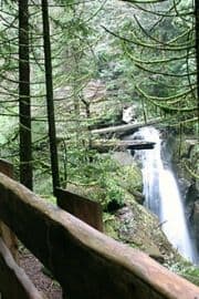
The trail is considered an easy going route measuring only 2-3 kilometres return. It is a one-way trail with a small loop route built into the centre of the trail.

At the top end of the loop route is a wooden bridge. The wooden bridge crosses the creek and enters a grove of 300 year old trees.

To get to the Upper Cypress Falls Viewpoint, do not cross the bridge, but instead, continue up the trail following the bank of the creek.

Most of the trail follows an earthy path surrounded by cedar and douglas fir trees. The trail can be slippery and muddy with some sections of exposed tree roots. Some sections explore near the edge of the canyon cliffs so please be careful.

Explore Cypress Falls Trail in West Vancouver, British Columbia, Canada

Address:

Cypress Falls Trail
Woodgreen Place
West Vancouver
Canada

How To Get ToCypress Falls Trail

:
Travel west from the community of West Vancouver to Exit 4. Take the exit and follow Woodgreen Drive. Continue up the hill and take a right on Woodgreen Place. At the end of the road is a gravel road which leads to the trailhead.
No reviews yet for Cypress Falls Trail.
Explore British Columbia

Come Experience the Nicola Valley!