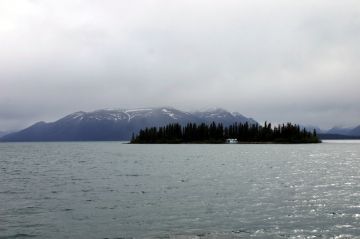
Atlin Lake

Park Amenities:
The Atlin Lakes are recreation marine destinations located in the community of Atlin, BC. The village of Atlin rests on the southeastern shore of the Atlin Lake. The lake stretches south to north with the northern tip of the lake connecting with the smaller Little Atlin Lake near the British Columbia\Yukon Border. Little Atlin Lake is actually located north of the border in the Yukon Territory.
Atlin Lake is said to be the headwater to the Yukon River. Both, Atlin and Little Atlin, are part of a chain of lakes which dominate the northwestern landscape of British Columbia and the Southern Lakes region of the Yukon Territory. During the summer months Atlin Lake attracts many activities to the region including canoeing, fishing, wilderness camping and boating.
The entire chain of lakes played a big part in the Klondike Gold Rush. Combined with the rivers, wagon roads and hiking trails - the lakes were the transportation routes used by miners to access the Yukon River. Later the Atlin Lake was serviced by the Tarahne Paddle Wheel Boat which transported people and supplies up and down the lake.
Atlin Lake was named by the the Tlingit First Nation people of the the region. To them the lake is not Atlin but "atlah" which means " big water". They got it right too because Atlin Lake is the largest natural lake in British Columbia, Canada measuring at 590 square kilometres.
Along the shores of the lakes are waterway channels and looming mountains. One can view mountains like Birch Mountain, Table Mountain and Mount Minto. By boat or canoe one can even view the glaciers in the Atlin Provincial Park and explore Teresa Island in the middle of Atlin Lake.
In the community of Atlin there is a marina and floatplane docks on Atlin Lake. There is a boat launch in town for accessing the lake. Fishing Atlin Lake is best by trolling. Most arrive to fish for Lake Trout, Whitefish and Arctic Grayling. Must have fishing license to fish in British Columbia.
Explore Atlin Lake and Little Atlin Lake near the Village of Atlin, BC, Canada
Address:


