Rivers Trail

Kamloops
British Columbia
Canada
Trail Length: 40+ kilometres
Difficulty: Easy - Family
Park Amenities:
Rivers Trail is a 40+ kilometre paved community path exploring the shores of the Thompson and North Thompson Rivers in and around the community of Kamloops, British Columbia, Canada. The trail system is, mostly, a walking and biking activity route connecting the downtown community with many of the local parks, historical sites, sightseeing viewpoints and outlying neighborhoods in the region.

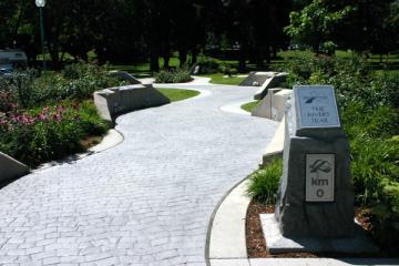
The Rivers Trail starts in downtown Kamloops from Riverside Park on the Thompson River. Some say the trail starts in Pioneer Park. Either-or you're close enough as the parks are side by side. Riverside Park is a sandy beach public park and the main park in the downtown core of Kamloops. It is here where a "Kilometre 0" stone monument marks the beginning of Rivers Trail.
The paved trail system is very well marked with trail signs and trail maps. From downtown the trail goes off in four different directions. Follow the Rivers Trail east for 3 km along the South Thompson River to the Secwepemc Museum and Heritage Park. This eastern route will soon expand and connect to the Kamloops BC Wildlife Park. The western route extends 19 kilometres following the Thompson River to Kamloops Lake and ending just short of Tranquille River and Cooney Bay. This route connects with McArthur Island Park and the Lac de Bois Grasslands Park. The southern route travels through the downtown streets of Kamloops, BC eventually connecting up with the Peterson Creek Nature Park trail system. Rivers Trail north follows along the North Thompson River for 13.5 kilometres. This route connects to Overlander Park, Schubert Lookout, Westsyde Centennial Park and ends at Harrington Road.
Shelters, washrooms, interpretive signs, sandy beaches, dog parks, museums, sitting benches, picnic tables, public art and drinking fountains are all located along the trail. It is important to pay attention to the trail signs at all times as they indicate the proper usage of the trail. All sections are designated hiker and walker friendly, while some designated routes allow dogs on a leash, biking and rollerblading. Please respect the signs.
The community of Kamloops, British Columbia has big plans for this trail. It is in the books to extend the trail to cover over 100 kilometres of paved pathway and to increase the number of interpretive signs posted along the trail.
Rivers Trail, Kamloops, BC, Canada in the Kootenays
Address:
Rivers Trail
Kamloops
Canada
How To Get ToRivers Trail
: No reviews yet for Rivers Trail.


