Crocus Bluff Nature Trail

Trail Length: 300 metres
Difficulty: Easy - Family
Park Amenities:
Crocus Bluff Nature Trail
The Crocus Bluff Nature Trail is a sightseeing interpretive trail leading to a wooden viewing platform in the community of Dawson City, Yukon Territory, Canada. The trail is an easy-grade, level hiking route exploring along a bluff located high above the community.
 The nature trail is named after the Crocus Flower. It is the first flower to bloom in the Dawson City area every year. Along the nature trail are interpretive signs. The signs discuss the history of the First Nation people and existence of the surrounding flora and fauna.
Some of the flowering plants on Crocus Bluff include lupine, bluebell, wintergreen, fireweed and lousewort. The regenerated forest surrounding the hiking trail is a mix match of trees ranging from black spruce, white spruce, aspen, paper birch, alder and willow trees.
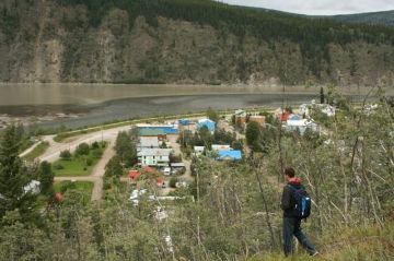
The highlight of the 400 metre Crocus Bluff Nature Trail is the viewing platform perched on a rocky bluff located at the end of the one-way trail. There are interpretive signs, viewing benches and rocky perches. From the lookout are views of the Klondike River and the community of Dawson City.
There is a pull out gravel parking lot on Old Dome Road (Mary McLoed Road) accessing the trailhead of the Crocus Bluff Nature Trail. There are pit toilets, interpretive signs and a trail map at the trailhead. The trail is a wide path with plenty of room. There are areas of exposed tree roots, but otherwise it is easy hiking to the lookout.
The Han Hwech'in First Nation (The River People) once scouted from Crocus Bluff watching for possible threats and visitors entering their territory. It was an important vantage point monitoring all of the activity entering and leaving the area via the Yukon and Klondike Rivers. The Han Hwech'in First Nation called the bluff a "Naket" - which means lookout.
There were tools and artifacts discovered on Crocus Bluff from the time of the Han Hwech'in First Nation people. It seems, from the story told by the artifacts, that while the First Nations kept watch on the bluff they would build and sharpen tools.
Crocus Bluff Nature Trail, Dawson City, Yukon Territories, Canada
Address:


