Gambier Island

Park Amenities:
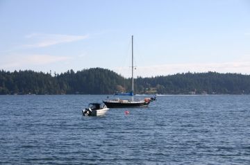
Gambier Island is located out in Howe Sound past Woolridge Island (smaller island between Sunshine Coast and Gambier Island). Gambier Island is a hiking, biking, camping, kayaking and boating rural retreat with many bays for moorage, camping and hiking trails. Trails like the hike to Elkins Point is very popular. From the lower Sunshine Coast side, the closest communities are Port Mellon and Gibsons, BC. Gambier Island, located north of Bowen Island, is accessed by personal boat, kayak, water taxi or by the Dogwood Princess passenger-only ferry.
By motorized boat the scenic tour over to Gambier is only 30 minutes short. The passage from Port Mellon through Thornborough Channel is mostly, protected waters away from the high winds (most of the time). The New Brighton ferry landing is in Thornbrough Bay, on the west side of the island.
Gambier Island, and the trip to, has many opportunities to view bird wildlife, the coastal mountains, seals and the marine activity of hard working tugboats pushing, pulling log booms. From Port Mellon, BC travelling around to the north side of Gambier leads to Douglas Bay and Brigade Bay which both have walk-in wilderness campsites. Take the time to view the waterfall near the Douglas Bay campsite. Continuing along the coastline of Gambier there are campsites also at Halkett Bay Provincial Park and West Bay.
Because Gambier Island is in the midst of other islands and islets many boaters and kayakers enjoy taking day trips from there base camp on Gambier. Trips to Anvil Island, north of Gambier and out to Christie Islet and Pam Rock are popular destinations. Like any ocean voyage, tours should only be attempted if the weather is on your side as heavy strong winds can kick up a fuss.
Gambier Island, Gibsons, BC, Sunshine Coast, British Columbia, Canada
Address:


