Indian Point - Evansville

Park Amenities:
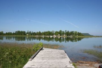
Indian Point is a picnic day use area and popular birding site situated at the end of a long peninsula with views of Lake Wolsey, Campbell Bay of Bayfield Sound and the Point Break Bridge.
The popular sightseeing and birding site, yet lacking crowds, is located on the west side of Manitoulin Island - northeast of the village of Evansville. Manitoulin Island, itself, is part of Rainbow Country in Northeastern Ontario.
The sightseeing road trip leading to Evansville is one of the more scenic inland drives on the island. On Highway #540, near Indian Point, Point Break Bridge is a long bridge, seemingly, floating on water.
Point Bridge crosses the channel separating Lake Wolsey and Campbell Bay. On the south end of the bridge is where you will find Indian Point. The lake park includes picnic tables, pit toilets, as well as, a boat launch.
The long bridge marks one of the more popular birding areas on the island. The best months for birding are from May to July. There are said to be over 280+ bird species sighted on Manitoulin Island. How many can you spot at Indian Point?
Birds sightings recorded in the area include common loon, great blue heron, sandhill crane, belted kingfisher, common merganser, American bittern, red-necked grebe, marsh wren, warblers, woodpeckers and bald eagles.
Explore & Visit Indian Point, Evansville, Manitoulin Island, Ontario, Canada
Address:
How To Get ToIndian Point - Evansville
:Drive (South Entrance) : From the ferry terminal in South Baymouth on Manitoulin Island travel north on Hwy #6. At the main junction take a left and travel northwest on Hwy #542 to Mindemoya. From Mindemoya continue on Hwy #542 towards Gore Bay. Just prior to Gore Bay travel west on Hwy #540 towards Evansville. Just prior to Evansville is Point Break Bridge. On the south end of the bridge is Indian Point.


