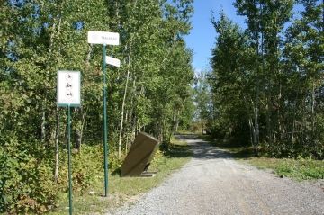
Scout Rock Trail

Trail Length: 4 kilometre
Difficulty: Easy - Family
Park Amenities:
Scout Rock Trail is an activity destination located in the community of Timmins, Ontario, Canada. The community of Timmins is located in the Wilderness Region in northeastern Ontario.
The Scout Rock Trail is a 4 kilometre (2.5 mi.) one-way, year-round recreation trail which explores a forest, some hills, a community neighbourhood and a marsh.
Located along the route are some great viewpoints overseeing the community of Timmins, Ontario.
The activity route is considered to be an easy going trail suitable for most ages. The mostly-level trail follows a gravel path starting from the local hospital and ending in Denise Park.
The adventure route is a popular summer trail for jogging, walking, birding, biking and dog walking (on leash). During the winter months the trail is used as a cross country ski route.
The trailhead to the Scout Rock Trail is located near the hospital in Timmins, Ontario. The first highlight on the trail is Scout Rock.
At Scout Rock the trail climbs a hill and enters a forest. The trail continues to a marsh area which are the headwaters of Town Creek. The trail then crosses two bridges. This is an ideal location for birding and sightseeing.
The trail then explores Melville Ravine. It is section of the trail which visits a residential neighbourhood with homes perched high up on both sides of the valley. The trail then climbs a small hill before it ends in Denise Park.
The Scout Rock Trail provides easy access to other trails including the Gillies Lake Promenade, the Hersey Lake Conservation Area, Lion's Park and the Golden Springs Trail.
Explore Scout Rock Trail, Timmins, Ontario, Canada, Wilderness Region
Address:
How To Get ToScout Rock Trail
:There are many access points along the Scout Rock Trail. Some of the better ones include the entrance on McLean Street and Denise Park.


