Badlands Trail
Difficulty: Easy - Family
Park Amenities:
The Badlands Trail is an easy-going, well maintained interpretive walking trail exploring the Canadian Badlands near the community of Drumheller, Alberta, Canada. The trail is a popular pathway for learning more about the geography and history of the Canadian Badlands.
 The educational trail is a 1.4 kilometre loop trail located on the same grounds as the Royal Tyrrell Museum. The Badlands Trail, together with the museum and McMullen Island, form the Midland Provincial Park.
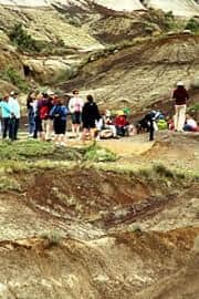
The Badlands Trail is a self guided trail which follows a well identified gravel path navigating around hoodoos and visiting the top of coulees leading to viewpoints and lookouts.
Hoodoos (aka fairy chimneys and earth pyramids) are tall rock pillars created from soft sedimentary rock topped with a harder rock which is more resistant to erosion from the elements like wind and rain.
Located along the pathway of this Drumheller park are 12 or more interpretive signs and stations providing information about the Canadian Badlands and dinosaurs. Some stations include sightseeing benches. Guided tours are available.
The Canadian Badlands are comprised from sea deposits sculpted by glaciation and years of erosion from winds and rain. The years of exposure have formed a landscape of coulees, hoodoos and river valleys.
The Sioux (First Nation people) call this type of landscape "Mako Sica" which means "the land is bad".
How to Get to the Badlands Trail:
Travel to the community of Drumheller, Alberta, Canada. From downtown Drumheller on main street (Centre Street) travel to 1st Avenue East and the Red Deer River Bridge. Cross the bridge and turn west onto North Dinosaur Trail (Secondary Road #838). Continue to Midland Park and the Badlands Trail. Midland Park is 6 kilometres from the community of Drumheller, Alberta, Canada.
Canada travel, tourism guide & directory
Address:

