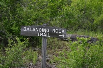
Balancing Rock Trail

Trail Length: 2 kilometres one-way
Difficulty: Moderate
Park Amenities:
The short 2 kilometre hike follows a dirt, earthy single-track path up the slopes of Mt. Creston via switchbacks, eventually, leading to a viewpoint, Ralph's Bridge, balancing rock and a small waterfall. Watch for loose shale rock, exposed tree roots and protruding boulders on the hiking trail. Good footwear is a good idea!

Near the 1360 metre (4420 ft.) summit, there is a ridge with a sitting bench providing fantastic views of the valley and wildlife reserve. The elevation gain from the parking area to the summit is 730 metres (2373 ft.). The trail may be short but it is all uphill to the summit.
Once on top of the mountain, we were pleasantly surprised to find so many, man-made balancing rock piles. Just down the trail was the Balancing Rock. It is a 400 ton granite boulder left behind by glacial drift.
From the summit the trail leads hikers back into the forests, down some more switchbacks, into a swamp and Ralph's Bridge. Watch for tree signs indicating the end of the trail. Because it is here that the maintained trail stops and the unmaintained trail begins.
The unmaintained trail does continue for another 3 kilometres reaching a dead end and an elevation of 3900 feet. This portion of the trail includes a side trail leading to a small waterfall.
The Balancing Rock Trail is an interpretive trail so make sure to pick up an information brochure at the trailhead. From the parking lot hike 50 metres in and you will come across an information box with an interpretive brochure inside so you can identify the flora and fauna along the trail.
Can you spot the Rocky Mountain Juniper, Kinnikinnick, Buffaloberry, Skunk Cabbage, Devil's Club, Indian Pipe, Sarsparilla and others.
There are no services on this trail like garbage cans or pit toilets. Plan well and do your business before the hike. Remember, you must pack out what you pack in. Leave no footprint behind.
Balancing Rock Hiking Trail, Creston, BC, Canada in the Kootenays
Address:


