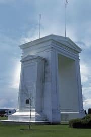
Peace Arch Provincial Park

Park Size: 16 hectares
Park Amenities:
The border separating Canada and the USA is named the Douglas Border Crossing. The community of White Rock and Surrey are the closest communities on the Canadian side and Blaine, Washington is the closest community on the United States side.
The Peace Arch Provincial Park measures over 16 hectares. It covers both sides of the Douglas Border Crossing. However, over 9 hectares of the entire park is located on the Canadian side of the international border.
The Canadian side of the park includes a floral garden, art sculptures, grass lawns, a playground, a pond, sitting benches and a picnic day use area. There is a historic picnic shelter in the park which was built in 1948. It is the oldest shelter in the Canadian parks system.
The symbol that dominates the skyline of the park is the massive stone Peace Arch. The arch sits one half on the Canadian side and one half on the American side.
The stone structure is a symbol of peace between the two nations. The arch represents the signing of the Treaty of Ghent which put an end to the 1812 war between the two nations. On December 24, 1814 the treaty was signed between Britain and the United States of America.
On each side of the Peace Arch are engravings. On the Canadian side it reads, "Brethren Dwelling Together in Unity," and on the United States of America side it reads, "Children of a Common Mother."
Explore the Peace Arch Provincial Park near White Rock, British Columbia, Canada
Address:


